


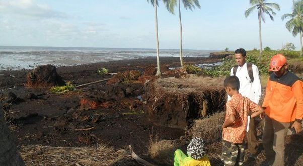
The land of Tanah Merah, Rangsang Pesisir Subdistrict, Meranti Islands District collapsed into the sea every year. In fact, the beach abrasion reaches 40 meters per year.
LAMANRIAU.COM, PEKANBARU – There are four peat islands in Riau Province threatened with sinking if they are not immediately rescued due to the abrasion of the Malacca Strait. The two islands in Bengkalis Regency include Bengkalis and Rupat Islands. Then there are the Meranti Islands namely Rangsang Island and Rokan Hilir Regency, Batu Mandi Island.
At the end of June 2019, a study became important to the public regarding the threat of sinking Bengkalis Island, Riau Province, due to the abrasion of the Malacca Strait.
The research was delivered by Professor of Yamaguchi University, Japan, Professor Koichi Yamamoto, in collaboration with the University of Riau (Unri). Instantly the research sparked public unrest in Riau.
The Central Government immediately held several meetings to overcome the worrying abrasion. This includes holding a Coordination Meeting by the Maritime Coordinating Ministry (Kemenko Maritim) on Tuesday, July 16, 2019, at the ministry’s office.
Reporting from the Facebook page of the Head of the Peat Restoration Agency (BRG), Nazir Foead, the coordination meeting was chaired by Coordinating Minister for Maritime Affairs Luhur Binsar Panjaitan and ATR/BPN Minister Sofyan Djalil, Riau Governor Syamsuar, BNPB Head Doni Munardo, BPPT Director, KLHK Director General, Deputy KSAL, KKP, Kemendes and LIPI discussed efforts to prevent abrasion on peat islands in Riau Province.
“The government is seriously concerned with the fate of the outermost peat islands, in addition to physical intervention also included the component of economic empowerment of peat communities/farmers in the action plan will be prepared by BPPT in the past two weeks with input from relevant Ministries and Institutions,” wrote Nazir Foead.
In his research, Koichi explained, peat on Bengkalis Island experienced landslides or peat slides and splashed into the sea or bog burst. The trigger for this process, besides deforestation and peat land use change, is also due to massive canalization as a drainage effort in the development of plantations and industrial plantations (HTI).
Japanese Environmental Engineering and Sediment Transport experts have conducted research for the past six years on Bengkalis Island, one of four islands located on the coast of Riau, located right on the lip of the Malacca Strait.
In the discussion, Yamamoto highlighted the important aspects he encountered in the field including peat failure and its impact on peat islands in Riau, including Bengkalis Island. Massive canalization as a drainage effort in plantation and HTI development is also the biggest contributor to the threat.
“The canals slice the peat dome and tear the integrity of the peatlands. As a result, when heavy rains fall, peat swell landslides and breaks down into the sea,” he explained. This process, he said, is very degenerative and threatens the existence of long-term peat islands.
“Through this process, the land of peat islands can disappear at a rate of up to 40 meters per year,” he said.
Meanwhile, Riau peat researchers graduating from Japanese universities, Dr. Prayoto said, he agreed with the results of Koichi’s research. Even though he had not read the full article from Koichi’s research results, Prayoto explained that abrasion on the Riau coast was increasingly alarming. In fact, the threat of abrasion does not only apply to Bengkalis Island, but also to other islands on the coast of Riau and directly facing the Malacca Strait. Like Rupat Island, it is also included in Bengkalis Regency and islands in Kepulauan Meranti Regency.
“Actually the abrasion caused by the beach waves in the Malacca Strait has been a long time ago. The waves in the Malacca Strait are also known to be very strong since long ago. Well, the question is why is abrasion getting worse now?” he said.
He explained, the core of the increasingly severe abrasion is that the planning implemented by the government on the islands is not adaptive. He gave an example, the granting of plantation permits and HTI concessions on peat contoured islands, such as Rangsang Island, Rupat and Bengkalis are the main sources of threat problems.
“We provide acacia and palm permits on islands. Like Pulau Padang, it is used as a stretch of acacia,” said the 39-year-old man who often came out of the peat island.
The plantation activity is often preceded by the making of canals and drying of water previously moistening the peat. As a result, the water in the peat disappears. When the dry season is prone to fire and the rainy season floods lurk. Drying also has an impact on decreasing peat soil.
Meanwhile, when the upstream part is damaged, the downstream part is on the automatic beach affected. Peat and mangrove on the shoreline of the islands are interrelated. The land is continuous. Peat water pushes down then downstream.
“It’s been dried, burned, we’re not ready for that condition,” he said.
The second problem, he said, was when the central government made a policy of saving peat islands, but did not include local residents. Prayoto dubbed himself a street child because he often walked in and out of peatland, claiming that this condition made the policy not going well.
“Central policy, they do not involve street children, who know the location that lives there. That is not yet there,” he said, saying the policy between the central government and local residents is like a relationship between a servant and his God.
He hopes that efforts to rescue the peat island are carried out comprehensively, and include local communities and researchers so that the threat of sinking the Bengkalis island and its surroundings can be overcome. (src)


